Great trekking and hiking trips in Europe in 2025/2026. Compare prices for 410+ trekking and hiking tours with 4410+ trip reviews. Book today and save up to 45% on Bookmundi.com!
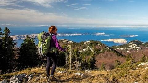
Get your hiking boots on! This tour is designed for experienced trekkers looking to explore exciting new places. You will spend overnight in two national parks, hike the well-known trails on Velebit Mountain, and enjoy the preserved nature and the views from the most beautiful summits of Croatia.
The routes you will pass through are some of the most exciting stages of the Via Dinarica trail on Velebit. From easy and moderately difficult to somewhat more demanding stages, this trail is perfect for advanced hikers searching for new excitement. Lace your hiking boots, prepare your backpack, and embark on a journey to Croatia.
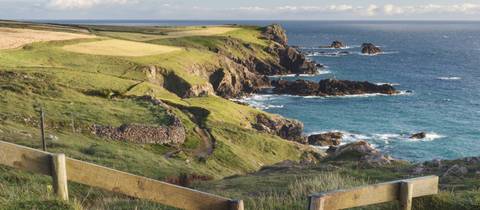
Follow the rugged Cornish Coastal Path from Padstow to Penzance in Cornwall. From Padstow to Penzance, this South West Coast Path adventure offers a rich blend of natural beauty and Cornish heritage in a 13-day itinerary. Follow the Camel Estuary and cliff-top paths past hidden coves and golden beaches to the surfing hub of Newquay. Explore ancient Iron Age forts at Trevelgue Head and spot remnants of Cornwall’s tin mining past near Perranporth and Portreath. Highlights include the dramatic cliffs at Hell’s Mouth, seal sightings near Godrevy Point, and a scenic walk through the Hayle dunes into charming St Ives. Beyond the cobbled streets and art galleries of St Ives, the trail continues past shipwreck sites like the Carracks, inland to Zennor, and along the rugged Penwith coastline. Visit iconic Land’s End, the cliffside Minack Theatre at Porthcurno, and the old smuggler’s pub , the “Lamorna Wink”. Pass through the picture-postcard fishing village of Mousehole (pronounced “Mowzl) and end your journey in the bustling coastal town of Penzance with sea views of striking St Michael’s Mount.
A mixture of coastal and moorland walking The Cleveland Way. Walkers familiar with Wainwright’s Coast to Coast path will already be well acquainted with a couple of spots along the rolling Cleveland Way such as The Wainstones, Urra Moor and Robin Hood Bay. In fact it shares about 10 miles of routing with the ‘C to C’. Maybe they will be intrigued enough by their flirtation with the trail to don their boots once again and take up the challenge of the 110 mile Cleveland Way route from Helmsley to Filey in its entirety. What stands out is the experience of half a walk over hill and scarp edges and half along the hilly coastline of the Yorkshire seaside. There is much to enjoy for those interested in history, those ‘collecting’ National Trails and for aficionados who wish to enjoy arguably the best Fish ‘n’ Chips in England at Whitby Bay! This is the second of the ‘National Trails’, dating from 1969 and is rooted in the North York Moors National Park / Yorkshire Heritage Coast. Along its length there are contrasts in walking between field - quilted farmlands, forest patches, dramatic sandstone rock scarps, bleak moorlands and the highly eroded coastline, punctuated by beautiful little fishing villages, clinging to the cliffs. It is an area that has been threatened by the expansion of the Tyne – Tees Conurbation on the one side and by the encroaching North Sea on the other. However apart from busy coastal towns such as Scarborough, it remains a tranquil area, bolstered and protected by the presence of the National Park of which about 80% of the walk occupies. Highlights of the Cleveland Way include, the remains of the Norman Rievaulx Abbey, and 13th century Whitby Abbey (but dating from the 7th century!), the Captain Cook Monument and Robin Hoods Bay with it's cliff-hanging cottages. Most of the route follows well sign-posted footpaths, which generally have good surfaces and are easy to follow. The exception to this is along the coastal path, which, in some places, is overgrown and uneven underfoot. The amount of daily ascent and descent is moderate, with much of the walk being on level or gently sloping ground. There are a number of steep ascents along the section from Osmotherley to Urra Moor and at some places along the coast, but these are generally of no more than one or two hundred metres at a time.
El Hierro is the least known, and most westerly, of the Canary Islands. In fact, it was the most westerly point of the 'old world'. El Hierro has escaped mass tourism and with a population of just over 6,500 it has a very different feel to the other Canarian islands. The Herrenos are fiercely proud of their island and are very welcoming towards visitors who come to appreciate the environment, such as walkers.
Like its neighbours, El Hierro was formed by volcanic activity along an offshoot of the mid-Atlantic ridge. There has not been an eruption on the island since the 18th century, but the cones of ash and old lava flows are a prominent feature of the island. The small central plateau, at 1000m or more, offers a mixture of volcanic scenery, pastures (cattle, sheep and goats provide fine cheeses), and the beautiful Canarian pine woodlands. To the north the lowland of El Golfo resembles a huge bite taken out of the island, and the impressive bordering escarpment, reaching 1500m in altitude, features in our walks. On the lower land of El Golfo vines, bananas and pineapples are grown. The islanders have preserved a number of local traditions and some of their sites are included in our routes. Overall, there is a surprisingly rich variety for such a small area!
The walking is designed to pass through the variety of landscapes on the island and to seek out the most spectacular views and a number of locations of cultural and historical significance to the islanders. No two days are the same. Your El Hierro experience begins in the small town of Valverde up on the plateau- the official capital of El Hierro. For early arrivals there are short walks locally to help you to get the feel of the island. From Valverde the route winds across the plateau, down to El Golfo and up again, then across to the far west of the island before heading back again across the plateau to descend and finish by the east coast.
You accommodation is a mix of simple and charming apartments and hostels, to 3 star hotels. All have restaurants either on site or very close by and so we have included half board for you on this holiday.
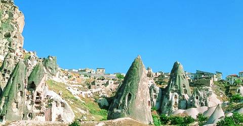
Early morning pick up from city hotels and transfer to airport in Istanbul for flight to Cappadocia. Meeting at Kayseri or Nevsehir Airport and transfer to Cappadocia to meet with the group and guide.
Walk through the “Fairy Chimneys” in Devrent Valley, Paşabağ (Monks’) Valley, practice pottery production with the ancient technique in Avanos. Visit to Göreme, the "open-air museum“ holding the earliest churches and chapels carved in fairy chimneys presenting finest examples of frescoes. Uçhisar Castle, the highest point in the region.
Lunch will be served during the tour.
Evening transfer to Kayseri or Nevsehir Airport for flight back to Istanbul.
Meeting at Istanbul Airport and transfer to hotels.
Are you looking for something unique out of Istanbul? This seven-day West Black Sea Tour offers an amazing route, which will take you away from the stressful city environment.
Starting from amazing Sile, we head to Agva to discover its pure natural beauty. Then, we will drive east along the West Black Sea toward Akcakoca, enjoying the beautiful scenery on the way. We will visit the old city of Akcakoca and other local attractions, including Genoese Castle.
Next up in our destinations are Bolu, home to the beautiful Lake Abant, and then the town of Safranbolu, famed for Ottoman architecture. The last stop of our tour is Amasra, a beautiful Black Sea port town, where we will tour its local attractions before returning to Istanbul to end our trip.
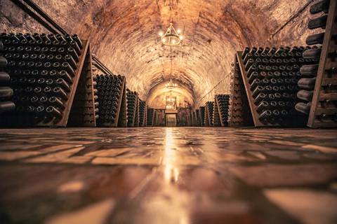
Known around the world for its wines, Champagne is also a popular destination for walking, offering an ideal playground. Walk among the vineyards and terraced hillsides where Champagne villages, chateaux, and churches are nestled. Enjoy panoramic viewpoints overlooking the vineyards and picturesque villages. The winemakers' open their doors to you, for tastings and tours of the cellars. They will passionately explain their know-how while showing you around their property.
During this tour, explore and taste every day what is hidden behind the bubbles that help us toast good news. Pop the cork and let the bubbles speak for themselves.
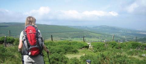
Experience superb walking through the spectacular Irish countryside near Dublin. The Wicklow Way is Ireland's oldest waymarked trail, pioneered by a famous hill walker, J.B Malone over 40 years ago and reveals some of Irelands finest views. Think Powerscourt Waterfall, Luggala, Loch Dan, Glenmalure Valley and historical Glendalough. The trail extends from Marlay Park in Dublin to Clonegal on the borders of Wicklow and Carlow covering a distance of approx 127 kilometres (79 miles). This 9-day trip covers the full Wicklow Way. The advantage of walking south to north means you will finish your walk in Dublin. For those a little shorter on time, there is a 7-day option that starts in Tinahely and takes you to Dublin.
The way winds through the Wicklow Mountains, one of Ireland's most spectacular upland areas. The Wicklow Way explores unspoilt trails, remote scenery, lakes, glacial valleys, forests and gentle farmland. Starting in southwest County Wicklow, the route passes through rural communities, old market towns and grand estates on its way to the bright lights of Dublin. Hiking near Dublin means a straightforward connection to the start of your trip, which is the small typical 'one street' village of Clonegal. An apt starting place for this walk into the remote and beautiful Wicklow Mountains. It is a route that remains mainly in the countryside making the short detours necessary to find a comfortable bed for the night.
A couple of fairly long but gentle days introduce you to the Newry Forest and over high points of Moylisha and Stookeen Hill to the 17th century village of Shillelagh and then on to the beautiful village of Tinahely. Quiet roads, forest trails and open mountainsides, with views back towards Clonegal and across the neighbouring counties of Carlow and Wexford, lead to Moyne and on to the most dramatic stages of the walk. A magnificent day's walk includes the spectacular Ow valley that passes below Wicklow's highest mountain, Lugnaquilla (925m), and along the 16km long glaciated Glenmalure Valley. This walk ends at the scattering of houses and splendid inn that make up Glenmalure hamlet. If climbing out of the Glenmalure Valley doesn't literally take your breath away then the fantastic views and the Glenmalure Waterfall probably will. Cross Mullacor Mountain and walk into Glendalough, 'the valley of two lakes' and site of a monastic settlement (from the 6th to the 13th century) for a little sightseeing. A short vehicle transfer gets you on the road to Oldbridge near Roundwood, which claims to be Ireland's highest village. The Penultimate day's walk is to the charming area around the village of Enniskerry. It is a mini classic with views of Lough Dan and Lough Tay. At the head of the valley is the Guinness family estate and later in the day enjoy views of Powerscourt Waterfall, the longest in the country. The last walk goes over Prince William's Seat for views across the city of Dublin, now in striking distance for some afternoon sightseeing and a lively evening in the city centre or one of its many fine restaurants.
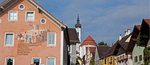
Walk in the footsteps of Bavaria's eccentric King Ludwig to Neuschwanstein Castle. Also known as the Koenig Ludwig Weg or King Ludwig’s Way. The eccentric Ludwig II succeeded to the throne of the then independent kingdom of Bavaria in 1864, as a youth of 18. On 13 June 1886 he and his physician Dr Godden were found dead in the water of the Starnbergersee (Lake Starnberg); the question still remains - Did Ludwig fall or was he pushed? He was a strong swimmer and a post-mortem established that he did not drown. But no one has succeeded in unraveling the mystery. The Koenig Ludwig Weg starts at the Votivkapelle (shrine), which marks the actual spot on the lakeshore ( near the hamlet of Berg) where the bodies were found. The route ends 60 miles away near Ludwig's own fairy tale castle at Neuschwanstein. This walk, which is one of the favourite longer walks in Germany, links places particularly dear to King Ludwig who was himself a keen walker. It is not a mountain walk and much of the route is on farm tracks and country lanes, but the surroundings are delightful, with a host of splendid buildings to admire in magnificent settings and plentiful opportunities to stop for refreshments! The plains surrounding Munich give way to gentle rolling hills that become ever higher as one approaches the great wall of limestone that marks the start of the Alps proper. The route passes two of Bavaria's most scenic lakes and through charming villages of geranium bedecked chalets with typical onion shaped church spires. There are masterpieces of baroque architecture, the Andechs monastery, the wonderful cathedral of Diessen on the Ammersee Lake; the monasteries of Wessobrunn and Rottenbuch, as well as the Wies or 'Meadow' church are on the route. The highest point (988m) on the walk is the summit of Hohenpeissenberg hill, considered by many to be the finest viewpoint in Bavaria. We end our tour at King Ludwig II’s most famous architectural masterpiece- the castle Neuschwanstein and at the nearby castle Hohenschwangau, both in Allgau on the Austrian border, where Ludwig spent most of his childhood. To celebrate the 150th anniversary of King Ludwig II (in 1995), the route was extended to begin at the Votivkapelle in Berg. It is a popular walk so early booking is recommended.