Hiking Table Mountain: Trails, Facts and Tips

- Anson M
- From
- Anson M
- From
- Mark G
- From
- Peter T
- From
1. Platteklip Gorge Trail
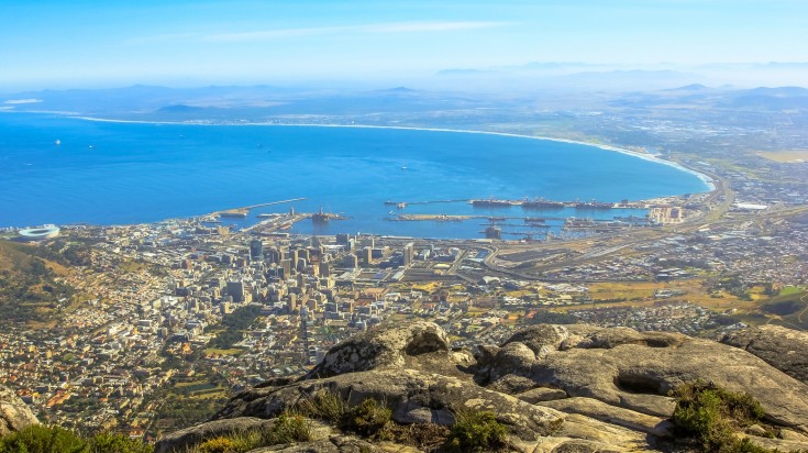
The most direct and popular trail up the mountain, Platteklip Gorge hike is a fairly steep climb because it doesn’t zig-zag to help reduce the abrupt change in altitude – it heads straight for the summit with no mercy. Don’t worry, though, because the view of the city below only gets better as you climb higher. Stop often to catch your breath and admire the sights of Cape Town and the Atlantic Ocean.
- Pros: Fastest and most direct route
- Cons: Popular and can get crowded. The entire trail is also in direct sun, so it gets very hot mid-day.
Hike facts
| Start and end location: |
East of the Table Mountain Aerial Cableway, which is a 15-minute drive from the city center. |
| Distance: | 2km |
| Duration: | 2 hours (one-way). For fit hikers, it’s possible to summit in 1 hour. |
| Difficulty: | Easy–moderate. Much of the “trail” is actually rocky, concrete stairs leading up to the summit — excellent if you’re into getting some serious exercise. It is classified as easy because you can stop and take a breather whenever you want, however the sheer steepness of the trail pushes it towards moderate. |
| Getting there: | The starting point takes off from the cable car parking lot on the Contour Path (look around for where the tour buses are parked — this is your clue). The first path forms a fork — you stay left. Stick to your right the next two junctions and you’ll hit Platteklip Gorge trail. |
2. India Venster Trail

This hiking trail charges straight up the front face of Table Mountain. The majority of the trail runs right underneath the cable car route and arguably provides the best views of the city below, although it is also the most challenging. Hikers tend to rate this trail as more scenic and interesting than Platteklip; the panoramas are pretty incredible. However, coming down the India Venster is more dangerous than going up, and is not recommended. It is slippery and steep. Consider taking another path or the cable car to return.
- Pros: The scenery and views
- Cons: Takes more time than Platteklip, requires a higher fitness level, and poses a higher danger level due to the sometimes-challenging terrain.
Hike Facts
| Start and end location: | The trail starts 50m to the right of the cable car station. |
| Distance: | 2.5km |
| Duration: | 2–4 hours (one-way) |
| Difficulty: | Moderate–difficult. This trail is the most challenging on our list in terms of terrain. It will require scooting, scrambling, and climbing over boulders. A relatively high fitness level is suggested if you plan on tackling this trail. |
| Getting there: | Take the Contour Path from the cable car parking lot. Continue until you see a green sign indicating you will climb “up.” Behind this sign is the start of the India Venster — it is not actually marked by name. Follow the blue or green spray paint markers on the rocks. |
3. Skeleton Gorge Trail
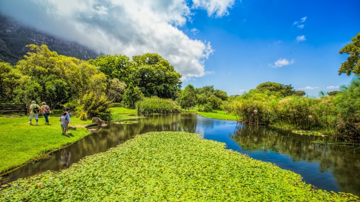
Kirstenbosch Garden in Cape Town, where Skeleton Gorge trailhead can be found
The Skeleton Gorge Trail allows you to enjoy nature and the hike as much as the view from the top of Table Mountain. The trail takes hikers through an emerald ravine, lush jungle, and shrub and moss-covered slopes before reaching the highest point of the mountain, Maclears Beacon. If you’re up for it, take the detour and check out Table Mountain’s only beach! You may be over a mile high, but thanks to the reservoir, you can enjoy a high-altitude paddle.
- Pros: Loads of flora, forest, and vegetation, and the second half of the hike boasts some lovely views of Cape Town.
- Cons: One of the longer routes and, unlike Platteklip or India Vesner, the beginning half doesn’t have any panoramic views of Cape Town. There’s also no sea view until you reach the top.
Hike Facts
| Start and end location: | Kirstenbosch National Botanical Gardens. The most popular route down is via cable car. |
| Distance: | 6.2km |
| Duration: | 3.5 hours to Maclears Beacon, plus another 45 minutes to the upper cable car station (one-way) |
| Difficulty: |
Moderate. It is a long hike and has occasional steep and strenuous passages. |
| Getting there: | Take the hop-on, hop-off bus or the Golden Arrow bus — both routes stop at Kirstenbosch Botanical Gardens, 15km away from the Aerial Cableway on the backside of Table Mountain. |
4. 12 Apostles Trail


If the view is your main objective during any hike, then this trail on Table Mountain is for you. The 12 Apostles are multiple peaks referred to as the “spine”, which is an incredible sight in itself. The entirety of the trek offers a bit of everything, which is why it’s so popular amongst hikers who not only want to get to the top of Table Mountain, but enjoy the journey, too! While it is a longer route, you’ll get to tramp through gorges, valleys, and plenty of fauna and flora. Views of the Atlantic Ocean, Lion’s Head, the suburbs of Muizenberg and the Cape Peninsula is definitely the icing on the cake.
- Pros: Less crowded that many other trails, it also avails some stunning views. A photo opportunity at the “diving board” – an iconic rock sliver jutting out of the mountain side and looking over the Atlantic Ocean. Sighting “tranquility cracks” which are big crevasses in the side of the mountain with amazing yellowwood trees growing within the labyrinth inside.
- Cons: It’s one of the longer hikes in the list, and there are no “city-bowl” views of Cape Town until you reach the top.
Hike Facts
| Start and end location: | Starts at ocean-facing Camps Bay, on the backside of the mountain. The end point is the same, however there is always the possibility to trek down an additional route or, if you’ve had enough hiking for one day, take the cable car. |
| Distance: | 6km |
| Duration: | 4–5 hours |
| Difficulty: | Easy. While this trail is longer than most of the others, it’s nowhere near as strenuous. You don’t have be super fit to take this challenge. |
| Getting there: | Camps Bay is located outside the Table Mountain National Park, 4km from the cable car station. The sign marked Camps Bay Pipe Track is your starting point. Form here, there’s roughly a 1.5-hour trek on the Kasteelspoort Trail until you reach the 12 Apostles. From here, you wind your way across the numerous jutting peaks, exploring all the nooks and crannies until you reach the top of Table Mountain. |
Good to Know
- The weather can change quickly and there’s an ever-present threat of the “table cloth”, a low-lying cloud cover that descends over the mountain. This cools the temperatures off considerably and, unfortunately, blocks the sprawling vistas. Be prepared for both!
- All visitors must pay the daily conservation fee. Your point of entry into Table Mountain National Park will dictate the cost.
- If your plan is to hike up and take the cable car down, be aware the cable car sometimes closes due to bad weather. This means you’ll be going down the same way you came up – via foot.
- For the above reason, it is recommended to hike in a group. If you are traveling to Cape Town alone, you might want to join a hiking tour.
- The dry summer months of November – February are the best times to hike Table Mountain. Warm weather and less chance of rain makes for much nicer and safer hiking conditions.
In Terms of Safety
- Don’t hike alone.
- Don’t flash your cash, wallet, or other valuables.
- Tell someone the route you plan to hike.
- If you get lost, stay where you are. You will be found if you’ve informed someone of your plan.
- If you hire a guide, make sure s/he is from a reputable company.
- Don’t follow people you don’t know.
- In the unlikely event where you are confronted by someone on the mountain, don’t resist handing over your valuables.
- Be aware and ready for harsh and sudden changes in weather. Pack extra (warm) clothes and waterproofs.
- If you run into any trouble, call Wilderness Search and Rescue +27 (0)21 948 9900, Table Mountain National Park +27 (0)21 957 4700, or for any other emergencies call +27 (0)21 480 7700.
What to Bring
- Sunscreen, sunglasses, and a hat for sun protection
- Plenty of water
- Layered clothes
- Guide map
- Money (there is a café and Wi-Fi lounge at the top!)
Whichever Table Mountain hiking trail you choose, the views from the top are beyond rewarding and absolutely breathtaking. Standing on the top of the mountain and looking down on Cape Town is something that every visitor should experience. Whether you bee-line it to the top, or take your time to enjoy all of nature’s glorious beauty, an experience of the Table Mountain is worth including on any South Africa tour.
You can also explore the travel itinerary options in our travel guide on how long to spend in South Africa. Feel free to contact our travel experts for a customized tour of South Africa.
For a seasonal overview, see our article on the best time to visit South Africa.


