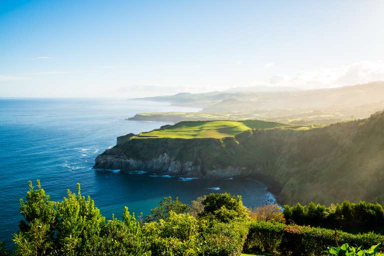
Hiking in the Azores: Best Trails, Maps and More


- David Stevens
- From
- David Stevens
- From
- Michelle K
- From
- Claire D.
- From
Best time to hike in the Azores
To take full advantage of the region's beauty, plan your trip to the Azores sometime between May and October. The weather in the Azores can be temperamental and unpredictable at any time of year, but expect a dry, mild climate during this period. There’s generally less rainfall and better visibility from late spring to early autumn, making for ideal hiking conditions. During the wet season from November to March, the trails can get muddy and slippery, so it's best to avoid hiking in the Azores then.
Top 10 hiking trails in the Azores
There are endless opportunities for hiking in the Azores, but these are some of the best trails to experience the region’s distinct and varied landscapes. Whether you are an experienced trekker or a beginner hiker, there is an opportunity to explore the beauty of the Azores on foot. We’ve provided some details, including length, where to start/end, and estimated time to complete, to help you decide which hike works best for you.
1. Miradouro das Lagoas – Poço do Bacalhau (PR03 FLO)


Soak up the spectacular scenery of Flores Island on this iconic Azores hiking trail. Starting at twin crater lakes and ending with cascading waterfalls, the trek includes many awe-inspiring viewpoints over the pastures of Fajã Grande where sprawling green meadows extend to the seaside.
- Location: Flores Island
- Hike type: Day hike, point-to-point
- Trailhead/end: Miradouro das Lagoas to Poço do Bacalhau (nearby Fajã Grande village)
- How to get here: If driving, go along Regional Road 2-2 and follow the detour to Lagoas Negra e Comprida, clearly marked between kilometers 8 and 9. The trail begins at the viewpoint between Caldeira Funda and Caldeia Comprida.
- Trail difficulty: Challenging; there’s a strenuous climb up the cliff with rocky and muddy terrain throughout.
- Distance: 7.3 km (to and back)
- Duration: 3 hr
2. Praia – Lagoa do Fogo (PRC02 SMI)


Starting in the charming village of Praia, this trail brings hikers through luscious forests and over rugged volcanic terrain on the way to the glistening Lagoa do Fogo. Hikers will pass the ruins of an ancient factory and enjoy the sweeping vistas of the countryside. While approaching the lake bank, exercise caution around the seagulls as they can be territorial, especially during the April – May nesting season.
- Location: Sao Miguel Island
- Hike type: Day hike, point-to-point
- Trailhead/end: Praia to Lagoa do Fogo
- How to get here: There is a parking lot near the official hiking trail sign, accessed off of EN1-1A. The location is marked on maps as Inicio Ruta PRC02.
- Trail difficulty: Moderate; the beginning of the hike is steep but a gradual climb and descent follows.
- Distance: 10.9 km (to and back)
- Duration: 4 hr
3. Caldeirão – Corvo (PRC02 COR)


A vast expanse of natural beauty awaits on the island of Corvo. From outside the Caldeirao crater, it’s impossible to imagine the sublime panoramas hidden inside, but as hikers ascend the outer ridge, they are met with endless pastures and picturesque lagoons.
- Location: Corvo Island
- Hike type: Day-hike, loop
- Trailhead/end: Caldeirão viewpoint
- How to get here: Start by the viewpoint of Caldeirão and walk down towards the boiler where you’ll find signs leading you towards the lagoon.
- Trail difficulty: Moderate; the end section up to the viewpoint can be difficult, though the rest of the hike is fairly simple.
- Distance: 4.8 km
- Duration: 2.5 hr
4. Rota dos Dez Vulcões (PR06 FAI)


The Dez Vulcões (10 volcanoes) hike is a geological wonder full of contrasting landscapes, from the rocky volcanic craters to the lush green meadows. Each of the volcanoes has a distinct appearance and unique history, giving insight into the eruptions that made Faial Island what it is today.
- Location: Faial Island
- Hike type: Day-hike, point-to-point
- Trailhead/end: Caldeira of Faial to Capelinhos Volcano Interpretation Center
- How to get here: Drive to the Dez Vulcões trailhead near the top of the Caldeira of Faial. There is a parking lot there, though you will need to take a taxi to return from the trail end on the west side of the island.
- Trail difficulty: Challenging; the trail has steep terrain and requires awkward footing on the ascent. Not for the faint of heart.
- Distance: 20.6 km (to and back)
- Duration: 7+ hr
5. Norte Pequeno (PRC06 SJO)


Explore the endemic flora and fauna of the Azores on this walk that brings hikers along the island cliffs, with dense jungle on one side and the deep-blue Atlantic Ocean on the other. The coast is dotted with quaint villages and breathtaking views, combining local culture with natural beauty.
- Location: São Jorge Island
- Hike type: Day-hike, loop
- Trailhead/end: Norte Pequeno village
- How to get here: Start at the old Norte Pequeno Parish Council and follow the trail markers along a dirt road to the left.
- Trail difficulty: Moderate; there are steep sections of the hike, but beginner hikers can make the climb by being careful and taking it slow.
- Distance: 10.8 km
- Duration: 3 to 4 hr
6. Pico da Vara (PRC07 SMI)


Hike through the Atalhada forest where indigenous flowers and trees line the pathway up to the incomparable Pico da Vara overlook. The trail leads up to the highest point on the island where the green mountains of São Miguel extend as far as you can see. This trail is a protected area, and you need to fill a mandatory online form before your trip.
- Location: São Miguel Island
- Hike type: Day-hike, out-and-back
- Trailhead/end: Casa de Guarda Florestal to Pico da Vara viewpoint
- How to get here: Drive or take a taxi to the Reserve of Atalhada parking lot. The trail begins from there at the Casa de Guarda.
- Trail difficulty: Challenging; the walk uphill is long and strenuous, with steep sections of muddy terrain.
- Distance: 7 km (to and back)
- Duration: 3 hr
7. Mistérios Negros – Terceira (PRC01 TER)


Taking hikers through storybook-like forests and expansive vistas, the Misterios Negros trail boasts a variety of extraordinary geosites. Hardened lava deposits form a jagged terrain amidst the grasslands, serving as a haunting reminder of the Azores’ volcanic past.
- Location: Terceira Island
- Hike type: Day-hike, loop
- Trailhead/end: Gruta do Natal (Christmas Cave)
- How to get here: Drive or take a taxi to the parking lot near Gruta do Natal and Lagoa do Negro where the signboard can be found and trail markers begin.
- Trail difficulty: Challenging; this trek requires climbing through rocky and uneven terrain. Especially after rain, the trail can be muddy and slippery, so bring proper footwear and exercise caution.
- Distance: 4.9 km
- Duration: 2.5 hr
8. Vista do Rei – Sete Cidades (PR03 SMI)


What was once a massive volcanic crater is now an idyllic sanctuary at Sete Cidades. The enchanting lagoons create a scene with intense hues of blue and green, making this hike an iconic Azores experience not to be missed.
- Location: Sao Miguel Island
- Hike type: Day-hike, point-to-point
- Trailhead/end: Vista do Rei viewpoint to Sete Cidades town
- How to get here: There is a parking lot located a short 20-minute walk from Vista do Rei viewpoint. You can drive or take a taxi there and then continue along the path to the right.
- Trail difficulty: Easy; some portions of the hike are steep, but the roads and paths offer decent traction and are doable for inexperienced hikers.
- Distance: 15.6 km (to and back)
- Duration: 5 hr
9. The Great Route of Santa Maria (GR1 SMA)


From its centuries-old villages to its stunning landscapes, Santa Maria is an untouched gem where time stands still. This iconic hike around the island offers an unforgettable experience through vineyards and beaches, to viewpoints and natural pools.
- Location: Santa Maria Island
- Hike type: Multi-day hike traditionally divided into four full-day stages (approx. 20 km each). Wild camping is forbidden, but tourist campsites and guesthouses are stationed at the endpoints of each section.
- Trailhead/end:
| Section | 1 | 2 | 3 | 4 |
| Start point | Vila do Porto | Cardal | Norte | Bananeiras |
| End point | Cardal | Norte | Bananeiras | Vila do Porto |
- How to get here: From Vila do Porto, walk to the Forte de São Brás where the official trailhead information board is.
- Trail difficulty: Moderate; to complete a section each day requires about 7 hours, so a good physical fitness level is required.
- Distance: 78.9 km
- Duration: 4 days
10. Sanguinho Trail (PRC09 SMI)


On this trail, hikers will stroll the “lost village” of Sanguinho and trek through vibrant vegetation. Walking through forests and farmland, every hiker can find something to enjoy about the Sanguinho Trail. To frontload the steep uphill climb, take the route clockwise and end at the Salto do Prego waterfall for a refreshing swim.
- Location: Sanguinho Island
- Hike type: Day-hike, loop
- Trailhead/end: Faial da Terra “Entrada” bus stop
- How to get here: Take a bus from the Faial da Terra village to the “Entrada” stop.
- Trail difficulty: Moderate; an easy hike overall with some brief but strenuous uphill climbs.
- Distance: 4.7 km
- Duration: 2 hr
The above are some of our favorite hiking trails in the Azores. Some of them are also included our list of best hikes in Portugal. You can easily add anyone of them to your private trip to Portugal or join a group hiking trip. For a personalized experience, reach out to our travel experts for a bespoke Portugal tour.
For information on all Azores hiking trails, check out Azores' official tourism website.